
Context: Nawada is being positioned as an integrated tourism destination by connecting Kakolat Waterfall, a major natural attraction, with Gunawa Jain Mandir and other religious, cultural and historical sites.
Key Details
- Kakolat Waterfall
- Located in Nawada district, on the Bihar–Jharkhand border. Situated on the Kakolat Hill.
- The waterfall descends from approximately 150–160 feet and forms a natural reservoir at its base.
- It is a major nature-tourism destination and attracts large numbers of visitors, particularly during summer.
- A three-day fair is associated with Bishua/Chait Sankranti.

- Gunawa Jain Mandir
- Located in Gunawa, Nawada.
- An important Jain pilgrimage site.
- Bihar Tourism states that Indrabhuti Gautam Gandhara, regarded as Lord Mahavira’s first disciple, is associated with attaining Kevala Jnana at this site.
- The temple complex is associated with Jain religious traditions and contains multiple temples.

- Integrated Tourism Approach
- The objective is to connect natural, religious, cultural and historical attractions rather than developing Kakolat as an isolated destination.
- Bihar Tourism already identifies eco-tourism and spiritual circuits, including Buddhist, Jain, Sufi, Ramayana and Sikh circuits.
- The Bihar Tourism Policy 2023 promotes sustainable tourism through renewable energy, electric/non-motorised transport, waste management, biodiversity protection, eco-tourism activities and bio-toilets. Eco-Tourism Projects are also eligible for tourism incentives, with a minimum project cost of ₹5 crore under the 2024 guidelines.
Five Eyes Security Cooperation
Context: The Five Eyes intelligence-sharing partners — Australia, Canada, New Zealand, the United Kingdom and the United States — held their annual Five Country Ministerial meeting in Sydney on 26 August 2026.
About Five Eyes
- Five Eyes is an intelligence-sharing and security partnership comprising USA, UK, Canada, Australia and New Zealand, with a major focus on Signals Intelligence (SIGINT).
- It originated from UK–US intelligence cooperation during World War II and was formalised through the UK USA Agreement (1946).
- Canada joined in 1948, while Australia and New Zealand joined in 1956.
- Its cooperation has expanded beyond intelligence sharing to counter-terrorism, cybersecurity, organised crime, foreign interference and emerging technologies such as AI.
- India is not a member of Five Eyes, but its activities are relevant to India’s counter-terrorism, cyber-security and Indo-Pacific strategic interests.
- Five Eyes cooperation on AI is not limited to the August 2026 ministerial meeting. In June 2026, the cyber-security agencies of the five countries issued a joint call for action on Frontier AI preparedness.
Significance for India
- Counter-terrorism: AI-enabled propaganda, radicalisation and extremist content can make terrorism prevention more challenging.
- Cybersecurity: AI can increase the speed, scale and sophistication of cyber threats, requiring stronger cyber resilience.
- Deepfakes & misinformation: AI-generated content can facilitate impersonation, misinformation and influence operations, creating risks for social and political stability.
- Intelligence cooperation: India can deepen information-sharing and technological cooperation with trusted partners to address emerging security threats.
- Indo-Pacific security: Five Eyes members are important strategic actors in the Indo-Pacific; their growing cooperation on AI and security has implications for India’s wider security environment.
India–China Boundary Talks
Context: India and China held the 25th Round of Special Representatives (SR) Talks on the boundary question in Beijing on 25 August 2026, led by Ajit Doval and Wang Yi. Both sides agreed to advance discussions towards an “early and substantial harvest” on boundary delimitation.
Key Details
- An Expert Group on Boundary Delimitation and a Working Group on Border Management will be established under the existing mechanisms.
- Both sides agreed to hold the next Expert-Level Mechanism meeting on trans-border rivers in September 2026, including hydrological data sharing.
- Two additional Border Personnel Meeting (BPM) points and two additional military hotlines will be established in the Eastern and Middle Sectors.
- The two sides reaffirmed the importance of the 2005 Agreement on Political Parameters and Guiding Principles for settlement of the boundary question.
India–China Border
- India shares a land boundary with China along Ladakh, Himachal Pradesh, Uttarakhand, Sikkim and Arunachal Pradesh.
- On the Chinese side, the border runs mainly along the Tibet Autonomous Region and Xinjiang.
- The boundary is divided into three sectors:
- Western Sector: Ladakh–Aksai Chin
- Middle Sector: Himachal Pradesh and Uttarakhand
- Eastern Sector: Sikkim and Arunachal Pradesh
- The McMahon Line, emerging from the 1914 Simla Convention, forms the basis of India’s boundary claim in the Eastern Sector, particularly Arunachal Pradesh. China does not recognise it and disputes India’s sovereignty over Arunachal Pradesh.
- Aksai Chin lies in the Western Sector and is claimed by India as part of Ladakh, but is under Chinese control. It is strategically important as it connects Xinjiang and Tibet and hosts the G219 highway.
Nepal Flash Flood: Bhotekoshi River Disaster
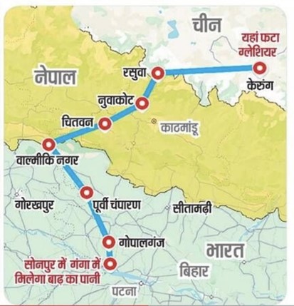
Context: A devastating flash flood struck Nepal’s Rasuwa district near the Nepal–China border on 26 August 2026, affecting settlements and infrastructure along the Bhotekoshi River. India has offered humanitarian assistance and coordinated with Nepal on rescue and relief efforts.
Key Details
- Location: Rasuwa district of Nepal, close to the Rasuwagadhi–Kerung border crossing with China.
- The flood entered Nepal from the Tibet side and affected areas along the Bhotekoshi–Trishuli river system.
- Preliminary assessments indicate that an ice-rock/debris event in the upper reaches may have blocked the Lhende River, followed by a sudden release of accumulated water. The exact trigger was still under investigation.
- The disaster caused extensive damage to roads, bridges, settlements, hydropower infrastructure and other critical infrastructure.
- The Bhotekoshi River subsequently feeds into the Trishuli River, making the event significant for downstream areas as well.
Why is Bihar particularly vulnerable?
- Since the Trishuli is part of the Gandak river system, the flood wave posed a potential downstream threat to Bihar and Uttar Pradesh.
- North Bihar’s major rivers—including Gandak, Kosi, Bagmati, Kamla and Mahananda—originate or have significant catchments in Nepal.
- The Government has noted that flooding in Bihar is strongly influenced by increased discharge from rivers whose upper catchments are largely located in Nepal.