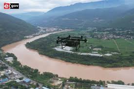
Uttar Pradesh’s High-Tech River Drone Survey Model
For the first time, a state has made such extensive and accurate use of a high-tech river drone survey system, which has facilitated the cleanup of rivers.
About River Drone Survey Model
The State Clean Ganga Mission has successfully completed a drone survey of approximately 150 kilometers of major rivers like the Ganga, Yamuna, Gomti, Varuna, and Pandu.
Regional Coverage: This survey was conducted in major cities like Lucknow, Prayagraj, Varanasi, and Kanpur.
‘Zero discharge’ plan in Kanpur: Based on the survey data, a detailed action plan for ‘zero discharge’ in rivers is being prepared.
Once implemented, it will completely curb the pollutants entering Kanpur’s rivers, allowing the rivers to return to their original state.
Gomti River Restoration: A drone-based comprehensive restoration plan is being developed for the Gomti River in the capital, Lucknow.
Drone-generated data, digital mapping and real-time monitoring are being used for drain tapping and restoration planning, reducing administrative delays and enhancing accountability.
The move away from paper-based processes towards data-driven governance has improved implementation efficiency and coordination among departments.
Significance: The survey has made it easier to identify the actual condition of rivers, the exact sources of pollution, and the illegal drains flowing into them.
It has also created new opportunities for sanitation, employment, and environmental protection in every village.
This convergence of Uttar Pradesh’s public welfare policies and technology has made the state a leading state in the country in the field of water conservation.