
Syllabus
GS 3: different types of irrigation and irrigation systems storage
Context:
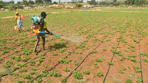
Researchers from IIT Bombay and IITM Pune have developed a Smart Irrigation Plan that can save 10–30% of water in drought-prone areas.
More on the News
- Researchers from the Department of Civil Engineering and Centre for Climate Studies at the IIT Bombay and the IITM Pune formulated a method to predict the amount of irrigation water needed up to three weeks, on a district and sub-district scale.
- The data on water consumption, monthly rainfall, root depth and irrigation water requirement data from the Food and Agriculture Organisation (FAO) resource were sourced from the IMD database and IITM Pune.
About the Research
- Researchers emphasized that farmers in drought-prone areas need a reliable irrigation plan due to unpredictable rainfall and limited groundwater.
- Knowing expected rainfall in advance allows farmers to plan irrigation better, supporting crop growth while conserving groundwater.
- The pilot study was conducted in Maharashtra’s Nashik district, where researchers found that a few grape farmers used local soil moisture sensors. Thereafter, the study extended its methodology in 12 sub-districts of West Bengal’s Bankura, a drought-prone district.
- During pilot study in Nashik, local weather forecasts were added to soil moisture data which showed that there could be savings up to 30% of groundwater.
- During the execution of the methodology in Bankura, they considered crop varieties, varied growth patterns, root zone depth and water requirements.
- Researchers fed weather forecast and soil moisture data into a computer model that checks the possible amount of rain, the water capacity of the soil and the water requirements of each crop.
- On the basis of these details, the system provides information on the crop’s water requirement. If the model predicts no rainfall in the coming days, it will suggest irrigating crops now.
- In case of rainfall arrival predictions, avoid irrigation of crops. This approach prevents overwatering the crops and saves water.
- The researchers highlighted that they used global soil maps and integrated satellite and field data to include soil moisture data such as root zone depth, soil texture, porosity, water-holding capacity, water conductivity and stomatal closure.
What is drought
- As per India’s High Powered Committee on Disaster Management, it refers to water shortage when usual needs of agriculture, livestock, industry or the population are not met.
- Drought is a prolonged period of abnormally low rainfall and moisture shortage relative to normal for a given location and season, resulting in water stress for humans, agriculture, ecosystems, etc.
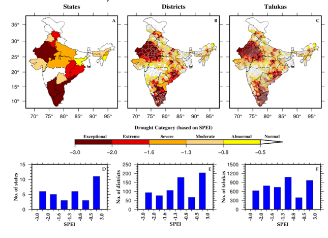
Drought-Prone Regions of India
- Over 60% of India’s districts are prone to floods and drought.
- Over 85% of such districts, prone to drought risk, are in Bihar, Assam, Jharkhand, Odisha, Uttar Pradesh, West Bengal, Karnataka, Tamil Nadu, Chhattisgarh, Kerala, Maharashtra, Uttarakhand and Haryana.
Challenges Highlighted by NDMA in Drought Management
- Different states follow different criteria and declare drought at different times.
- The indicators and methods used to assess drought intensity and monitor it vary widely across states.
- There is a lack of proper data sharing for drought assessment and declaration.
- Many agencies do not fully use ICT tools to manage drought effectively.
- Rainfed areas often lack check dams, leading to poor water storage during droughts.
- Community participation in drought management is low, and Self Help Groups, NGOs and the corporate sector are not actively involved at the village or tehsil level.