Context:
Recently, Scientists have detected a lost Mayan city using Light Detection and Ranging (LiDAR).
More on the News

- The city had two major centres and included temple pyramids, amphitheatres, and a reservoir.
- They believe it is second in density only to Calakmul, thought to be the largest Maya site in ancient Latin America.
- Archaeologists also found the remains of residential buildings, terraces, field walls, garden areas, stabilized hills and other signs of human industry.
Mayan Civilization
Originating in the Yucatán peninsula around 2600 B.C., the Mayan Civilization rose to prominence around A.D. 250.
The civilization occupied much of the northwestern part of the isthmus of Central America, from Chiapas and Yucatán, now part of southern Mexico, through Guatemala, Honduras, Belize, and El Salvador and into Nicaragua.
This civilization began approximately 2500 B.C and ended around 1500 A.D, spanning three different eras.

- 2500 B.C to 250 A.D: Less nomadic, settled down in one area, planted crops like corn called maize.
- 250 A.D to 900 A.D: Pyramid/temple building, explored math/astronomy, hieroglyphics (writing).
- 900 A.D to 1500 A.D: Civilization began its decline; some Mexicans were considered as descendants.
- Today, there are still over 6 million Maya people living in the same region, and they speak more than 28 surviving Mayan languages.
Light Detection and Ranging (LiDAR)
- It is a remote sensing method that uses light in the form of a pulsed laser to measure ranges (variable distances) of a sensor to the Earth’s surface.
- Its data can be used to create high-resolution 3-D models of ground elevation with a vertical accuracy of upto 10 cm.
- Lidar systems allow scientists and mapping professionals to examine both natural and manmade environments with accuracy, precision, and flexibility.
- LiDAR is closely related to RADAR (Radio Detection and Ranging) in the sense that both use remote sensing technologies to detect and map objects.
- The main difference between RADAR and LiDAR is the type of electromagnetic wave they use. While LiDAR uses light waves, RADAR uses radio waves.
How does LiDAR work?
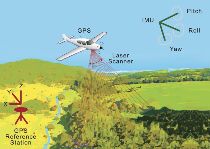
- LiDAR instrumentation comprises a laser, a scanner, and a GPS receiver. The rapidly firing laser travels to the ground and then light reflects or scatter, and is recorded by the LiDAR sensor.
- The system calculates the light pulses’ by two-way travel time to arrive at the distance between the terrain and the sensor using Global Positioning System (GPS) and Inertial Measurement System (IMS) data, to create an elevation map of Earth.
- Two types of lidar are topographic and bathymetric. Topographic lidar typically uses a near-infrared laser to map the land, while bathymetric lidar uses water-penetrating green light to also measure seafloor and riverbed elevations.

