

SYLLABUS
GS 3: Disaster and disaster management.
Context: India’s high vulnerability to frequent and diverse extreme weather events, such as floods, cyclones, and heatwaves, led to the development of an integrated early warning system like the Multi-Hazard Early Warning Decision Support System (MHEW-DSS) to improve disaster preparedness and reduce losses.
About the Multi-Hazard Early Warning Decision Support System (MHEW-DSS)
- It is a digital platform that automates the decision-making on critical weather forecasting processes and forecast and warning services to the public, government, and non-government agencies, as well as specific stakeholders.
- It has been developed by the India Meteorological Department using open-source technology and in-house expertise.
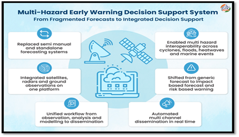
- Launched under Mission Mausam in January 2024, it combines satellite, radar, and other observational data with advanced forecasting tools and utilises Geographic Information System (GIS) maps for efficient collection, analysis, and dissemination of weather data.
- It delivers real-time, impact-based multi-hazard forecasting across India, empowering decision-makers and communities by translating complex meteorological data into actionable warnings.
- It also includes a public platform named Mausamgram, which provides hyper-local weather forecasts by entering the name of the place or the Pincode of the place. It reflects the Government of India’s vision of a “Weather Ready and Climate Smart Nation” and embodies the philosophy of “Har Har Mausam, Har Ghar Mausam.
Salient Features of the MHEW-DSS
- Automated Weather Data Processing: Over 90% of weather data collection, quality checks, and integration are automated.
- Better Use of Forecast Models: More than 95% of numerical weather prediction model inputs are now used in forecasting.
- Longer Forecast Lead Time: Forecast lead time has increased from 5 days to 7 days.
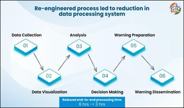
- Faster Forecast Preparation: The time required to prepare forecasts has reduced by about 3 hours from 6 hours.
- Cost Savings and Self-Reliance: The system has generated around ₹250 crore in cost savings and eliminated dependence on foreign vendors.
- Reduced Evacuation Costs: Improved early warnings have helped reduce evacuation costs to one-third from 1999 to 2024 due to a reduction in cyclone landfall point forecast error in the 3-5 days ahead forecast issued by IMD.
Operational Architecture of the MHEW-DSS
- Weather Analysis and Forecast Enabling System (WAFES) helps forecasters analyse data, generate charts, and visualise weather conditions through GIS-based maps.
- Using a GIS-enabled platform, it integrates colour-coded alerts for various hazards and disseminates them through digital channels like SMS, emails, Application Programming Interface (API), Mobile App (Mausam), Common Alerting Protocol (CAP) and graphical bulletins to ensure timely action and disaster preparedness.
System Characteristics of the MHEW-DSS
- Interoperable: Different modules work together on one platform, allowing easy sharing of data across ministries, departments, and sectors using common standards.
- Scalable: The system can easily grow over time—adding new data, technologies, regions, and types of disasters without major changes.
- Replicable: It is built using standard methods, making it easy to use in other sectors and even by other countries.
- Efficient: Real-time forecasts and impact-based warnings have reduced preparation time by 50% and improved accuracy by 30%.
- Responsive: The system is user-friendly and dynamic, sharing information through multiple channels such as SMS, APIs, mobile apps, and websites.
- Transparent: Clear data processes and open systems make it easy to track, verify, and ensure accountability.
- Sustainable: Supported by long-term planning, regular training, system upgrades, and continuous knowledge sharing.
Significance of the MHEW-DSS
- Cyclone and Marine Safety: Provides early warnings for cyclones and severe weather, issuing alerts for fishermen when wind speeds exceed 45 kmph, with updates shared via SMS, apps, and broadcasts to ensure timely safety measures.
- Human Health:
- Weather data facilitates heatwave forecasting, emergency health preparedness for vulnerable groups, and the prediction of vector-borne diseases like dengue and malaria.
- It also provides air quality and temperature advisories to strengthen community resilience and preventive health measures.
- Energy Sector: Provides weather forecasts for renewable management, protects infrastructure with early warnings, and uses automation to reduce costs and save 210,240 kWh annually.
- Water Resource Management:
- Optimizes weather forecasting, flood control, and irrigation efficiency.
- Digital workflows save 63 kilolitres of water annually by eliminating paper chart production.
- Livelihood Protection: Provides timely weather data to safeguard assets, plan safely, and secure livelihoods across key sectors.
- Strengthening Governance:
- Digital transformation has streamlined forecasting workflows across 40 offices, improving accuracy and inter-agency coordination.
- This shift saves ₹57.6 crore annually and provides critical data to over 200 organisations, including NITI Aayog and NDMA.
SOURCE
PIB